1/7
Helmand River (Middle Reach) Flood Hazard Map screenshot 0
Helmand River (Middle Reach) Flood Hazard Map screenshot 1
Helmand River (Middle Reach) Flood Hazard Map screenshot 2
Helmand River (Middle Reach) Flood Hazard Map screenshot 3
Helmand River (Middle Reach) Flood Hazard Map screenshot 4
Helmand River (Middle Reach) Flood Hazard Map screenshot 5
Helmand River (Middle Reach) Flood Hazard Map screenshot 6
Helmand River (Middle Reach) Flood Hazard Map Icon

Helmand River (Middle Reach) Flood Hazard Map

Karimullah Sefat
Trustable Ranking Icon
1K+ดาวน์โหลด
63MBขนาด
Android Version Icon7.0+
เวอร์ชั่นแอนดรอยด์
1.0.2(07-11-2020)
-
(0 รีวิว)
Age ratingPEGI-3
ดาวน์โหลด
รายละเอียดรีวิวข้อมูล
1/7

คำอธิบายของHelmand River (Middle Reach) Flood Hazard Map

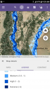
Rivers give life, connect and shape societies and have a high influence on civilization. Living along the riversides is the enjoyment of nature, but river floods usually face societies to extreme damages. Thus, adequate information about behavior and flood of the rivers is a must for adapting and land use planning in such hazard-prone zones.


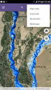
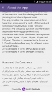
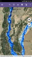
Helmand River Flood Hazard Map provides a comprehensive overview of the riverine flood hazards along the banks of Helmand and Arghandab Tributary River inside Helmand province that threaten the area currently, as well as how these hazards are likely to increase in the future. And tells you a bunch of key information obtained by hydrological and hydraulic calculations with floods of different return periods (e.g. 2-year, 5-year, 10-year, 25-year, 50-year, and 100-year). The data is presented in the format as:

1. Flood Inundation Boundary for different return periods of floods.

2. Flood Hazard in terms of Inundation Depth.

3. Flood Hazard in terms of Depth x Velocity.


The information provided in this app is intended to enable more informed decision-making by residents, property, and business owners, farmers, engineers, and policymakers.


Helmand River (Middle Reach) Flood Hazard Map--เวอร์ชั่น1.0.2

(07-11-2020)
ข่าวใหม่This app provides information about flood hazardous areas along the banks of Helmand and Arghandab Tributary River inside Helmand province. Flood-prone areas of different return periods flooding (e.g. 2-year, 5-year, 10-year, 25-year, 50-year, and 100-year) are presented in the format as:1. Flood Inundation Boundary for different return periods of floods.2. Flood Hazard in terms of Inundation Depth.3. Flood Hazard in terms of Depth x Velocity.

ไม่มีการรีวิวหรือให้คะแนน! ก่อนออกโปรด

-
0 Reviews
5
4
3
2
1

Helmand River (Middle Reach) Flood Hazard Map - ข้อมูล APK

เวอร์ชั่น APK: 1.0.2แพ็คเกจ: com.HelmandRiver.FloodMapsApp
แอนดรอยด์ที่เข้ากันได้: 7.0+ (Nougat)
นักพัฒนา:Karimullah Sefatอนุญาต:4
ชื่อ: Helmand River (Middle Reach) Flood Hazard Mapขนาด: 63 MBดาวน์โหลด: 0เวอร์ชั่น : 1.0.2วันที่ปล่อย: 2020-11-07 21:33:27หน้าจอขั้นต่ำ: SMALLCPU ที่รองรับ: arm64-v8a
ID ของแพคเกจ: com.HelmandRiver.FloodMapsAppลายเซ็น SHA1: DD:6D:D6:1B:88:D2:BA:6B:FD:EF:C7:1B:D4:4D:C8:7A:40:CC:55:61นักพัฒนา (CN): Androidองค์กร (O): Google Inc.ท้องถิ่น (L): Mountain Viewประเทศ (C): USรัฐ/เมือง (ST): California
appcoins-gift
เกมส์ AppCoinsรับรางวัลมากยิ่งขึ้น!
เพิ่มเติม
Seekers Notes: Hidden Objects
Seekers Notes: Hidden Objects icon
ดาวน์โหลด
The Ants: Underground Kingdom
The Ants: Underground Kingdom icon
ดาวน์โหลด
The WalkingDead: Survivors
The WalkingDead: Survivors icon
ดาวน์โหลด
Last Day on Earth: Survival
Last Day on Earth: Survival icon
ดาวน์โหลด
Matchington Mansion
Matchington Mansion icon
ดาวน์โหลด
Legend of Mushroom
Legend of Mushroom icon
ดาวน์โหลด
Stormshot: Isle of Adventure
Stormshot: Isle of Adventure icon
ดาวน์โหลด
Heroes of War: WW2 Idle RPG
Heroes of War: WW2 Idle RPG icon
ดาวน์โหลด
Star Trek™ Fleet Command
Star Trek™ Fleet Command icon
ดาวน์โหลด
Gods and Glory
Gods and Glory icon
ดาวน์โหลด